I'm about 100m up the mountain when a glint of light catches my attention. I look back at the village of Gokyo and see a headlamp, about 15 minutes behind me. For reasons I cannot explain, it spurs me to go faster, especially when it appears the lamp is gaining on me. I suppose I'm more competitive than I realize.
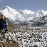 |
| Gokyo Ri |
I blithley take a 360 degree panorama shot. A guide is among the next folks up and he is kind enough to point out the major mountains to me. I will never remember their names, but I will find a photo in Kathmandu that has all the peaks labeled. He points out Everest, which has been hiding behind the sun, and it looks more prominent from this vantage point than from any other I've seen.
I linger at the top, wanting to bask in this beauty, but knowing I have a LONG day ahead and I need to get going. I make it back down to lodge a little after 8AM, pack, have some tea, and say my good-byes to Didi at 9AM. While having tea, I look at the map and set some milestones along the way so I have some idea of when I will arrive in Namche. I estimate 4 hours to Dole and 6 hours to Namche.
I make a slow start but pick up steam along the way. Villages are located in ravines so they have water sources. The trail drops at least 100m into each village, and then climes back up 50m or so on south side of each village. I encounter a village every hour and stop each time on the climb out of the ravines, taking some water and eating a snack. I make my 4 hour estimate for Dole but the push for Namche takes another 4 hours, ughhh. The last hour is really painful as my feet start to hurt and the trail skirts the mountain on which Namche is situated. The mountain is very serrated so you keep rounding corners, thinking that Namche must be around the next corner, only to find yet another corner ahead.
I get myself situated in a guest house in Namche and then think about dinner. I have lugged around a full bottle of beer (650ml - heavy!) so that I could get a picture of a local Nepal beer with Mt. Everest in the background. Niall Battson makes a calendar every year with a local beer in front of a famous monument or site in different countries around the world. I figure he can use one with Mt. Everest in the background. However, Now that it has served its purpose, I'm intent to consume it and my thought is to make a special sandwich with French bread, cheese and salami.
There is no "French" bakery in town but many of the villages in Nepal have German bakeries, so I check this option. They have no French bread so I get a brown loaf. They also have some cheese. I ask whether there is a place to get salami and they point me across the street to a grocery store. I check with them, but they tell me that salami has a shelf life of only 1 month and you won't find anything in Namche unless it has a shelf life of at least one year! He points me to some luncheon meat and I make do with that.
I eat half my sandwich before pitching it out in disgust. It's just not the same as originally envisioned. But the beer is great! (although at 3400m, it fizzes a lot when you pour it)
No comments:
Post a Comment